The Cravens House Loop Trail is a fun Chattanooga hike on Lookout Mountain!
You start at the historic Cravens House and make your way up Lookout Mountain. Huge bluffs and breathtaking views of Chattanooga and the Tennessee River and valley make this a must-hike in Southeast Tennessee!

The Cravens House Loop Trail is approximately a 4.2 miles loop and has a 728 ft. elevation gain. We would rate this trail as “Easy to Moderately Strenuous”, with the only strenuous part being the Gum Spring section because it is a pretty steep climb up to the Bluff Trail. But it is definitely not dangerous. Just take your time and stop for a breather when you need it!
It is called the Cravens House Loop Trail but it is actually composed of several Lookout Mountain trails, or sections of some longer trails. The trails are the Rifle Pits Trail, the Upper Truck Trail (section), the Gum Springs Trail, the Bluff Trail (section) and the Cravens House Trail. They all come together to make a great “loop trail” experience, complete with historic landmarks, beautiful mountain scenery, epic views and a good dose of exercise!

The Cravens House Loop Trail parking area is the parking lot for the historical Cravens House, located about halfway up the side of Lookout Mountain, overlooking the city of Chattanooga.
Just head towards St. Elmo and follow US 11 (Cummings Hwy) until the signs for Hwy 148, which goes up Lookout Mountain. Turn left on 148 and continue up the mountain. Not too far beyond the Ruby Falls entrance, you will see a sign for Military Rd. Turn right on that road and then follow the signs to Cravens House. The road is narrow so keep an eye out for on-coming traffic.
Before even starting down a trail, explore the Cravens House and enjoy the fantastic view from the front porch. Then head to the right from the parking area to start the trail and be sure to take a look at the map posted at the trailhead.

At the start you will see a Cravens Trail sign where the trail splits. The Cravens House Trail on the left heads up to the bluff and the Rifle Pits Trail is to the right.
This is the start of the loop. You can do the loop clockwise or counter-clockwise, it’s up to you! We chose to start the loop by taking the trail to the right, the Rifle Pits Trail.

The Rifle Pits Trail wanders through the forest, offering up great mountain scenery with impressive moss-covered rock formations along the way.

And you are walking through an area that saw heavy action during the Civil War. The Confederates had dug rifle pits to head off a charge by Union soldiers. The trail has numerous markers and signs documenting the historical sites along the way.
Since this was a winter hike, we had the bonus of great views through the trees of the river and the bend.

You soon come to a trail intersection where you bear left onto the Upper Truck Trail section of the hike. At this point you can easily walk side by side while taking in the scenery.

Not too far down this section of the hike, you come to another historical marker for Camp Demaray, a CCC (Civilian Conservation Corps) complex that was home to many working men during the Depression years of the 1930s. You can take a little time from your hike to roam the remains of one of the original structures.
Continue on and appreciate this wide, flat trail while you have it!

After a short hike, you will come to another intersection where the Guild Trail joins the Upper Truck Trail from the right. As the small sign indicates, bear left to continue on the Upper Truck Trail.
You soon come to a point where the Gum Spring Trail crosses over the Upper Truck Trail. This is where you leave the flat, comfortable trail and begin an ascent on the Gum Spring Trail! Just look for the brown trail sign on the left and begin the 0.6 mile ascent to the Bluff Trail!

This is a steady climb but there’s plenty of scenery to distract you along the way. A short hike up brings you to Gum Spring on the left. But you must keep on truckin’! When you need to, just stop for a breather and take in the great view.
You arrive at the top where the Gum Springs Trail intersects with the Bluff Trail. There are endless incredible views up here!
Turn left on the Bluff Trail and you soon come to a brown trail sign indicating the directions to Sunset Rock, Point Park, Covenant College and Skyuka Springs.

Head up to Sunset Rock for a breathtaking vista! You have a fairly steep ascent but there are rock steps along the way to help. We didn’t head up there on this hike (it looked a bit “busy”) but we have visited it before and it is well worth the climb!
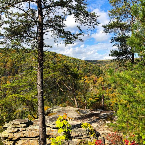
Continue along the Bluff Trail and get ready for overwhelming scenery! The Bluff Trail truly delivers! You have massive walls of sandstone cliffs towering to your right and sharp drop-offs to the left!
But the trail doesn’t leave you at great risk. The outward side of the trail is lined with rocks in many of the steeper sections.
And there were a few large, muddy sections on the day we hiked due to recent rain.

Take time to savor the views of the Tennessee River and the distant mountains as you hike this section of the Bluff Trail.
You remain on the Bluff Trail for approximately 0.6 mi before reaching the next trail intersection where you will see a posted map. Bear left to follow the Cravens House Trail that completes the loop.

This 0.5 mi section of the trail begins the gradual descent back to Cravens House and makes up for the Gum Spring climb!
The trail is still a bit rocky but the mountain scenery continues to be enjoyable.

Hike to the Cravens House parking area and take some time to explore the historic area around the house.

We thoroughly enjoyed the Cravens House Loop Trail! With its magnificent mountain scenery, majestic mountain views and all the historic relevance, you can’t go wrong with this hike!


Leave a Reply